Product Description
This is an introductory course to GIS including basic information on: Geographic Information System, spatial data (raster and vector model), coordinate systems, attribute and spatial queries, simple analysis using geoprocessing tools, and data visualization.
Learning outcomes
Understand the basic concepts of Geographic Information Systems.
Define terms related to raster and vector data models (e.g. pixel, grid, spatial resolution, attribute table, topology).
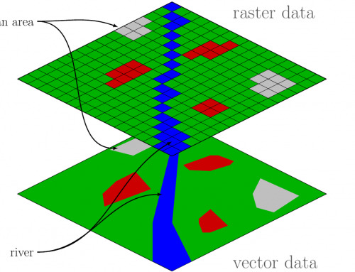
Compare vector and raster data models.
Understand the difference between geographic and projected coordinate systems.
Select objects using attribute and spatial queries.
Perform simple analysis with geoprocessing tools.
List map elements and basic principles of map creation.
Create a thematic map using different methods of symbolization.

BoK concepts
Links to concepts from the EO4GEO Body of Knowledge used in this course:
- > AM | Analytical Methods
- > AM2 | Query operations and query languages
- > AM2-2 | Structured Query Language (SQL) and attribute queries
- > AM2-3 | Spatial queries
- > AM4 | Basic analytical operations
- > AM4-2 | Buffers
- > AM2 | Query operations and query languages
- > CF | Conceptual Foundations
- > CF6 | Relationships
- > CF6-3 | Topological relationships
- > CF6 | Relationships
- > CV | Cartography and Visualization
- > CV3 | Design principles
- > CV3-1 | Map design fundamentals
- > CV3 | Design principles
- > DM | Data Modeling, Storage and Exploitation
- > DM4 | Vector data model, Feature based modelling, Applications
- > DM3 | Tessellation data models
- > DM3-2 | The raster model
- > GD | Geospatial Data
- > GD1 | Geolocating Data to Earth
- > GD1-4 | Map projections
- > GD1 | Geolocating Data to Earth
Material preview
Ownership
Designed and developed by: Anna Adamowicz, UNEP/GRID-Warsaw Centre.
Contributors: Maria Andrzejewska, Elżbieta Wołoszyńska-Wiśniewska.
License: Creative Commons Attribution-ShareAlike.
Education level
EQF 4 (what is this?)
Language
![]() English
English
Creation date
2020-08-26
Access
Find below a direct link to the HTML presentation.
Find below a link to the GitHub repository where you can download the presentation.