Product Description
This is a slideset for city planners about Urban Heat Islands and the importance of their identification in a spatial planning context. The slideset introduces the EO surface temperature maps, with their potential and their limitations.
The lecture is accompained with the registration of a webinar held on February 3rd 2021 on the same topic organized by Epsilon Italia and Geografiska Informationsbyrån (GiB).
Learning outcomes
Understand the importance of identifying UHIs in a spatial planning context.
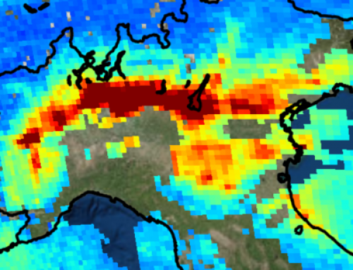
Understand how EO surface temperature time series can support identification of UHIs.
Understand how to interpret EO surface temperature time series to identify UHIs.
Understand how to derive maps from EO surface temperature data, to be integrated with other relevant information related to UHI identification in a spatial planning context.
Understand how to analyse information derived from EO surface temperature data integrated with other relevant information related to UHI identification in a spatial planning context.
Understand the limitations of the EO surface temperature data due to the spatial resolution.

BoK concepts
Links to concepts from the EO4GEO Body of Knowledge used in this course:
- > IP | Image processing and analysis
- > IP3 | Image understanding
- > IP3-11 | Time series analysis
- > IP3 | Image understanding
- > PP | Physical principles
- > PP1 | Basics of Optical Remote Sensing
- > PP1-1 | EM radiation
- > PP1 | Basics of Optical Remote Sensing
- > TA | Thematic and application domains
- > TA13 | EO services and applications
- > TA13-5 | Monitor the built environment
- > TA13-5-1 | Monitor urban areas
- > TA13-5 | Monitor the built environment
- > TA14 | Standard EO products
- > TA14-2 | Descriptive analytics products
- > TA13 | EO services and applications
Material preview
Webinar registration
Ownership
Designed and developed by: Giacomo Martirano, Lisa Bilotti (Epsilon Italia) and Greger Lindeberg, Sara Wiman (Geografiska Informationsbyrån – GIB).
Contributors: Spatial Services GmbH, University of Zagreb Faculty of Geodesy.
Education level
EQF 4 (what is this?)
Language
![]() English
English
Creation date
2020-11-16
Access
Find below a direct link to the HTML presentation.
+ | The presentation and the webinar recording are also available in our eLearning platform.
Find below a link to the GitHub repository where you can download the presentation.
License: Creative Commons Attribution-ShareAlike.