Product Description
Acourse on the use of Earth Observation data and services to assess the landslide risk affecting Cultural Heritage sites.
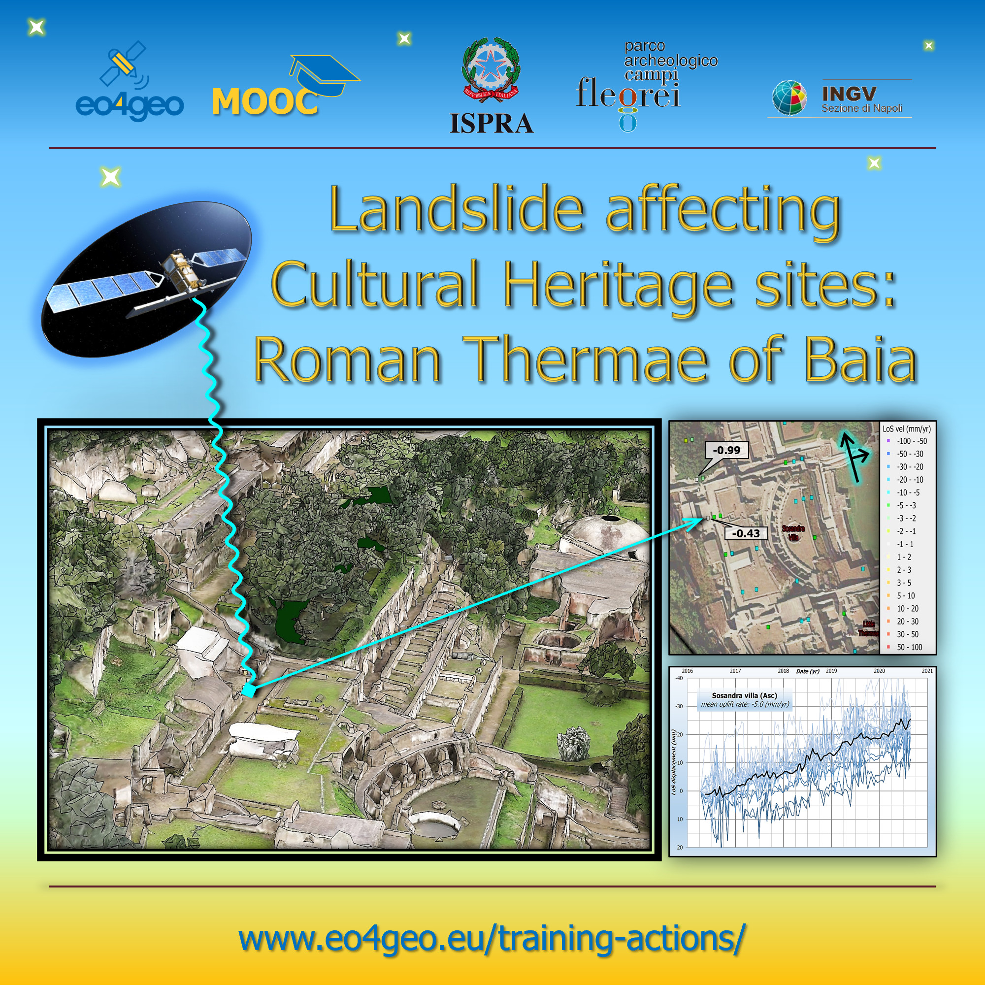
The course focus on the use of Copernicus EO data and services to assess the landslide risk affecting the tufaceous volcano slope on which the Baia Roman Thermae are built on. The Persistent Scatterers processing allows to perform ground displacement analysis focused on the detection of historical and recent landslides, thus helping technicians and site managers to properly address mitigation actions for the best conservation of Cultural Heritage.
The Roman Thermae of Baia are located in Bacoli municipality (Naples), close by the Phlegrean Fields caldera, representing a unique example of volcanic-related bradyseism with unrest cycles characterized by intense ground uplift and sinking
InSAR data processing will take into consideration COSMO Sky-Med datasets and the most recent SENTINEL-1 data, allowing us to assess the instability phenomena evolution of the area in a recent time interval.
The course objective is to spread and encourage the use of satellite radar data for deformation analyses, not only in geological and environmental applications but also in the management and conservation of built heritage in cultural sites. The use case aims at proposing a simple and easy-to-use methodology to exploit Persistent Scatterer Interferometry (PSI) data related to the Roman Thermae of Baia.
Learning outcomes
Recognize and explain at a basic level fundamental physical principles of remote sensing.
Recognize and explain basic computational properties of remote sensing data acquisition.
Evaluate the qualitative/quantitative uncertainty and limitations of data.
Carry out pre-processing and processing of InSAR data.
Schematically diagram what is happening to data in a particular analyses or set of analyses and analyse how that influences interpretation of results.
Carry out hypothesis-driven analyses involving spatially referenced data, interpret the results, analyse uncertainties and limitations of interpretations.
Critically analyse pre-existing data.
BoK concepts
Links to concepts from the EO4GEO Body of Knowledge used in this course:
Ownership
The course is designed and developed by ISPRA, the The Italian Institute for Environmental Protection and Research in collaboration with the EO4GEO project.
Education level
EQF 6 (what is this?)
Language
![]() English
English
Creation date
December 2021
Access
| This online course consists of 7 lectures made of slide presentations and 4 self tests. A participation certificate is available.
License: Creative Commons Attribution-ShareAlike.